Take a breath of fresh air and explore the outdoors in the Lost Sierra. Take time to stretch your legs and take the scenic route.
The Lost Sierra is a haven for outdoor enthusiasts, offering trails that are primed for hiking and biking with scenic views of wide-open vistas. Bike expansive rail-trails, paving complete with rolling river views and an ode to the region’s history. Raft, kayak, and tube your way along the MANY rivers in Sierra and Plumas Counties.
Get your adrenaline fix mountain biking and cliff jumping into the lakes. Explore all that the region has to offer with the beautiful Plumas National Forest, and regional trail networks highlighting connections across the Lost Sierra.
The best way to catalog adventure – and the surefire way to happiness – is to go out and seek it, and then get your Tail on the Trails.
The Lost Sierra Route is a new master plan project created by the Sierra Buttes Trail Stewardship. Learn more about it and watch their new video, A Trail for Everyone…
For decades crowds have flocked to Lake Tahoe and the central Sierra, and the exquisite ruggedness of Yosemite, Kings Canyon, and the eastern Sierra. And while anglers, hikers, and horse people have long recreated in the northern Sierra, it was the mountain bike crowd that really started turning outsiders on to the unspoiled grandeur of northern Sierra, a region that has come to be known as The Lost Sierra.
The Lost Sierra’s evocative name is only the beginning of its charms. This outdoor playground at the northern end of California’s Sierra Nevada mountains is the quintessential summer mountain getaway, especially for those looking to escape the crowds of more common destinations like Tahoe and Yosemite.
The area lies about four hours’ drive northeast of San Francisco, or 1.5 hours northwest of Lake Tahoe. Two charming small towns – Sierra City and Downieville – lie along Highway 49, while Gold Lake Highway cuts north toward Graegle through the alpine granite of Lakes Basin Recreational Area. Around and between these towns and highways lie opportunities for hiking, mountain biking, camping, boating, fishing, rock climbing, swimming hole dunking and beer drinking. What’s not to love?
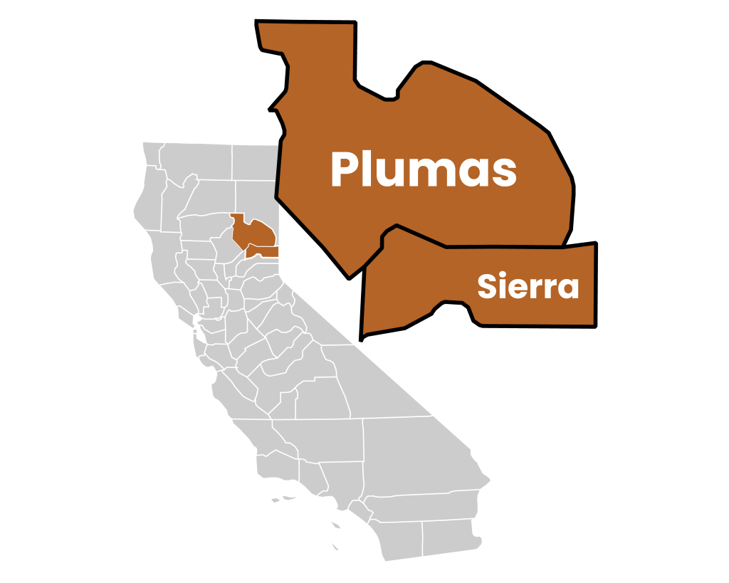
Communities in the Lakes Basin area grew from gold prospecting in the 19th century and persisted during the movement of that time toward recreation and relaxation in the outdoors. That legacy continues today in sites like the Wallis Mine, located along the Deer Lake Trail, and relics of the lost era are still left to rust all over the basin alongside the living monuments to modern-day adventures. But the Lakes Basin has also preserved a portion of its indigenous history as well. An interpretive trail near Elwell Lodge in Lakes Basin Recreation Area describes petroglyphs inscribed by Native Americans in millennia past. The Lakes Basin comprises lands once inhabited by the Maidu people, and though there is some confusion on the source of the petroglyphs, they are attributed to the Maidu.
A good place to start, Bear Lakes Loop via Round Lake (5.0 miles) offers a tour at the heart of Lakes Basin that touches or overlooks six of the area’s innumerable lakes.
Frazier Falls is a waterfall of nearly 250 feet, and it is positioned just a short walk on paved trail from the highway.
Rock Lake and Jamison Lake(6.0 miles) are moderately easy to hike to and feature beautiful views of granite peaks and opalescent pools.
Sierra Buttes is one of the most dramatic scenes in the area, and the Sierra Buttes Fire Lookoutis the prized vertiginous perch at the end of the Sierra Buttes Trail. The peak is the tallest in the Lakes Basin region at 8,857 feet.
The (awesome) Mills Peak Lookout was restored and reactivated for fire service in 2005. The first lookout at this site was built in 1933. This lookout is on the National Historic Lookout Register #602.
The views from the top of the trail make for amazing photo ops. We highly recommend this moderate one way trail to Mills Peak in the Plumas National Forest.
Walk at the foot of towering volcanic peaks and peer into pools of geothermal water and mud at Lassen Volcanic National Park. Step from the rocky landscape into serene woodland to discover a variety of animals living in the challenging environment. In the heart of the park, look up to see Lassen Peak climbing to a height of 10,457 feet (3,187 meters), making it the world’s largest plug-dome volcano. Although it is classified as active, the most recent eruption subsided in 1917. All visible volcanic movements now occur elsewhere within the park. View thermal activity easily from the sidewalk at Sulphur Works. Stroll along the 3-mile (5-kilometer) Bumpass Hell Trail to get close to the Big Boiler steam vent. Watch thick mud rise and fall in brown bubbles and smell the sulfur that emanates from vents rising from deep within the earth’s crust.
If you’re looking for a piece of untouched wilderness that isn’t completely overrun with tourists, then Lassen Volcanic National Park is absolutely worth exploring.
From vast and diverse landscapes and epic hiking trails to geothermal and volcanic activity, there’s a lot to discover at this northern Californian park.
You might want to check this hidden gem off your bucket list before more people catch on to how great it truly is!
Mountain Biking the Downieville Downhill for Non-Expert Riders
The Downieville Downhill is one of the best known mountain bike trails in the US, and it’s for good reason. The trail is unique, challenging, and a blast to ride. The network of trails around Downieville is growing, thanks to the hard work of the Sierra Buttes Trail Stewardship, but the classic route is 15 miles with nearly 6,800 feet of descent.
After this long, difficult, but incredibly fun and rewarding ride, there’s nothing better than jumping in the North Yuba River which has its confluence with the Downie River almost directly across from Yuba Expeditions bike shop.
The entire length of the Pacific Crest Trail is open to riders and their horses.
A ride on the PCT makes lifetime memories and enhances that special relationship between horse and rider. The Pacific Crest Trail goes through the Lost Sierra as well, with Sierra City and Quincy being popular town stops for thru hikers. Day hikes on this section of the PCT will take you to some incredible places and views. The trail runs through the Sierra Nevada and Cascade mountain ranges from the Canada-US border in the north all the way to the US-Mexico border in the south. It is 2,659 miles long, reaches a maximum elevation of 13,153 feet at Forester Pass in the Sierra Nevadas, and dips all the way to near sea level at the Washington-Oregon border. Each year thousands of hikers enjoy one of the westernmost and diverse American hikes in the PCT.
Zoom back in time at Plumas-Eureka State Park in the Sierra Nevada and Cascade Range. Prospectors discovered gold here in 1851 and, over the course of nearly a century, more than $8 millions’ worth was mined from what was creatively known as Gold Mountain and is now called Eureka Peak. The mountain still contains about 65 miles of mining tunnels.
The only gold you’ll find here is on the trees come autumn, but you can still get into a Gold Rush state of mind. Tour the quaint brick-red museum, explore the mills, and during the annual “Gold Discovery Days” in July, watch a blacksmith make mining tools, pretend-pan for gold, and take a hay ride.
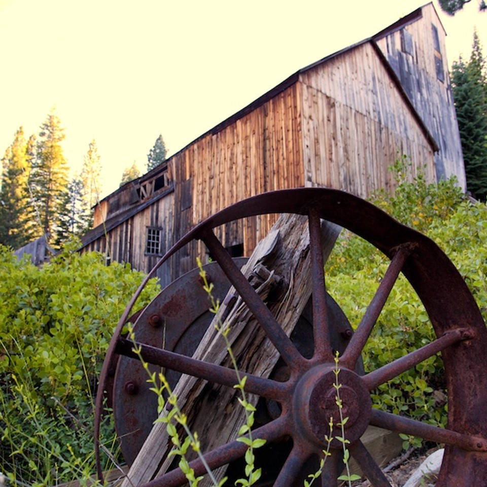
Sierra City is one of those tiny, relaxed, outdoorsy mountain towns perfect for a summer getaway. It boasts a handful of restaurants, one small grocery store, some charming places to stay and opportunities for cooling off in the North Yuba River running adjacent to town.
The town of Sierra City is also a popular resupply stop for Pacific Crest Trail hikers; the trail crosses the highway just outside town. We were there at the height of PCT season (late June / early July) and really enjoyed the vibe as these hikers chowed down on massive sandwiches and pints of ice cream on the front porch of the town general store. In town there are some rustic cabins and other nice places to stay, but for many this area is all about the camping.
Lake Almanor – 52 miles of lake shoreline just waiting to be explored. A top-rated fishing destination year-round in California and home to the annual professional bass tournament, Lake Almanor is a classic American family lake destination!
Boat Rentals, Kayaks and guide services are all available around the Lake in multiple locations, and the Town of Chester on the North edge of the Lake has all the rural town amenities you would like on a family vacation, including burgers & ice cream cones, fuel stops and more.
Explore huge diesel locomotives, historic cabooses and more at this remote and rarely open museum. The Western Pacific Railroad Museum features dozens of historic locomotives, coaches, cabooses and more. Keep scrolling for the full tour.
Adjacent to the railyard, aging locomotives, boxcars, and cabooses sit like forgotten toys of a giant trainspotter. Once powerful and remarkable machines, they now rest quietly in a retirement of cold winters and high altitude. For a few days a week, during just a few months of every year, you can explore these well-worn machines. This is the Western Pacific Railroad Museum, a unique and impressive collection and easily one of the best museums of its type in the country!
The High Sierra Music Festival, held annually at the Plumas County Fairgrounds, might seem like an odd place for the epicenter of the West Coast summer jam scene. It’s a tiny logging and mining town that hasn’t changed much over time. Set off Highway 70, just east of the picturesque Feather River canyon, it both braces and embraces every July 4.
The hippies cometh and the 29th annual HSMF continued the traditions over the four-day Independence Day weekend. Escape was the name of the game, in a Las Vegas sort of way; though substitute pine forest and 3,500 feet of elevation for the glitz of the strip. Attendees came as they were, or as whomever they wanted to be. Each day there was an aspirational dress “theme,” but that didn’t always work out. High Sierra was a camping festival, with most staking out their claim for the duration.